
Chasing Waterfalls in the Catlins, New Zealand
Wondering which waterfalls you should stop at in the Catlins? Let me help you decide which ones are worth the visit if you’re short on time and can’t see them all in one trip. It can be hard to choose from all the different falls, but I’m here to make it simple for you!

Starting with the most popular waterfalls and ending with some lesser known, hidden gems! Make sure you stick around towards the end because number 7 is my personal favorite of them all.
Mclean Falls


One of the most popular falls in the Catlins, and for good reason! If it weren’t always so busy, this would easily be my favorite. Mclean Falls is an impressive 22 meters tall and cascades down into several smaller falls. This track is well maintained, easy to follow and family friendly. From the carpark, it’s a slow but steady uphill walk alongside the river until you eventually walk right up to the edge of the waterfall. Expect to spend 40 minutes total on the Mclean Falls track.
How to Get to Mclean Falls
Turn off the Chaslands Highway onto Rewcastle Road, 11.6 km south of Papatowai. You will see a big yellow sign for Mclean Falls and will drive past the Whistling Frog Holiday Park. Continue driving on this gravel road for 3km until you reach the car park.
2. Purakaunui Falls

Purakaunui Falls is one of the most photographed waterfalls in the South Island, so be prepared for crowds. The falls are surrounded by lush green forest and cascade down across 3 main tiers, about 10m in height. This track is a short, flat and easily accessible 20 minute return walk. Read the full Purakaunui Falls Walk trail guide.
How to Get to Purakaunui Falls
There’s a few different ways to access Purakaunui Falls. If you’re heading South, I recommend turning off the main highway onto Purakaunui Falls Road, 6.3km South of Owaka. You’ll drive on this road for 8.3km until reaching the trailhead. If you’re heading North, I would turn off Papatowai Highway onto Waikoato Valley Road. Drive on Waikoato Valley Road for 4km and it will turn into Purakaunui Falls Road 350m before you reach the carpark.
3. Matai Falls

Matai Falls is the first of two waterfalls on the Matai Falls Track. It’s only a 10 minute walk from the carpark until you eventually reach an intersection dividing the track left and right. Take the path to the left to reach Matai Falls. The path to the right leads you to Horseshoe Falls, which I talk about next!
How to Get to Matai Falls
The trailhead is located just off the Papatowai highway, 18km South of Owaka. There is a sign indicating where the carpark is, look for a dirt pullout.
4. Horseshoe Falls
Horseshoe Falls is the second waterfall on the Matai Falls Track. 10 minutes into the track you will reach an intersection, take the path to the right. You will reach Horseshoe Falls after a further 5 minute climb up some stairs. This track is definitely worth a stop considering you get to see two waterfalls in just one short walk!
How to Get to Horseshoe Falls
The same exact way you reach Matai Falls. Turn into the Matai Falls carpark just off the main highway, about 18km South of Owaka.
5. Punehu Falls

Punehu Falls is the lower waterfall on the Waipohatu Loop Track. This is the longest track of all the Catlins Waterfall Walks, but I highly recommend it because it’s a lesser known trail featuring two impressive waterfalls! This trail can be completed as a 6km out-and-back walk or an 8km loop, with both options taking about 2-3 hours. Whichever you decide to do, start the walk in a counter clockwise direction. A moderate fitness level and good hiking boots are highly recommended because this is a very muddy trail. Read my comprehensive guide to the Waipohatu Walk here.
How to Get to Punehu Falls
From Haldane-Curio Bay Road, turn onto Waipohatu Road. The carpark is just 1km further, and if you want to make your hike a little bit shorter, keep driving to the second carpark. Once on the Waipohatu Loop Track, begin hiking in a counter clockwise direction for about 3km until you reach a signed intersection directing you left or right. Take the path to the left and you’ll reach Punehu Falls in just under 5 minutes.
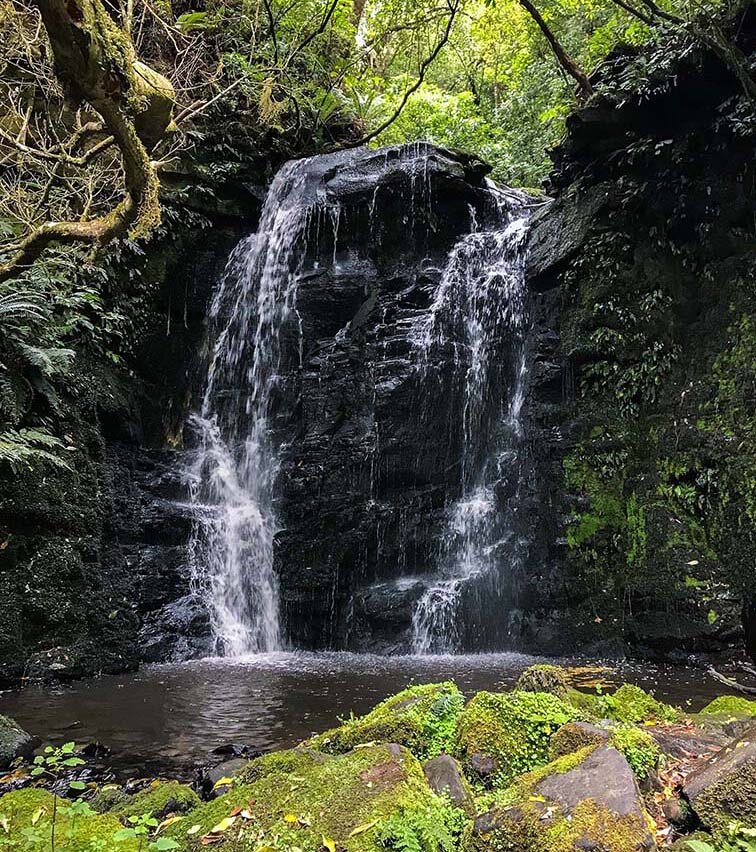
6. Pouriwai Falls

Pouriwai Falls is the upper waterfall on the Waipohatu Loop Track. This is a powerful waterfall plunging into a pool of water 10 meters below. To get the best view, you may have to attempt a relatively fast stream crossing if it’s recently rained. Please do so carefully and at your own risk. Find detailed trail directions to the Waipohatu Waterfall Walk here.
How to Get to Pouriwai Falls
Same exact driving directions as Punehu Falls. Once on the Waipohatu Loop Track, walk for 3km until you reach an intersection guiding you left or right. Take the path to the right and after 5 minutes of walking you’ll reach Pouriwai Falls.
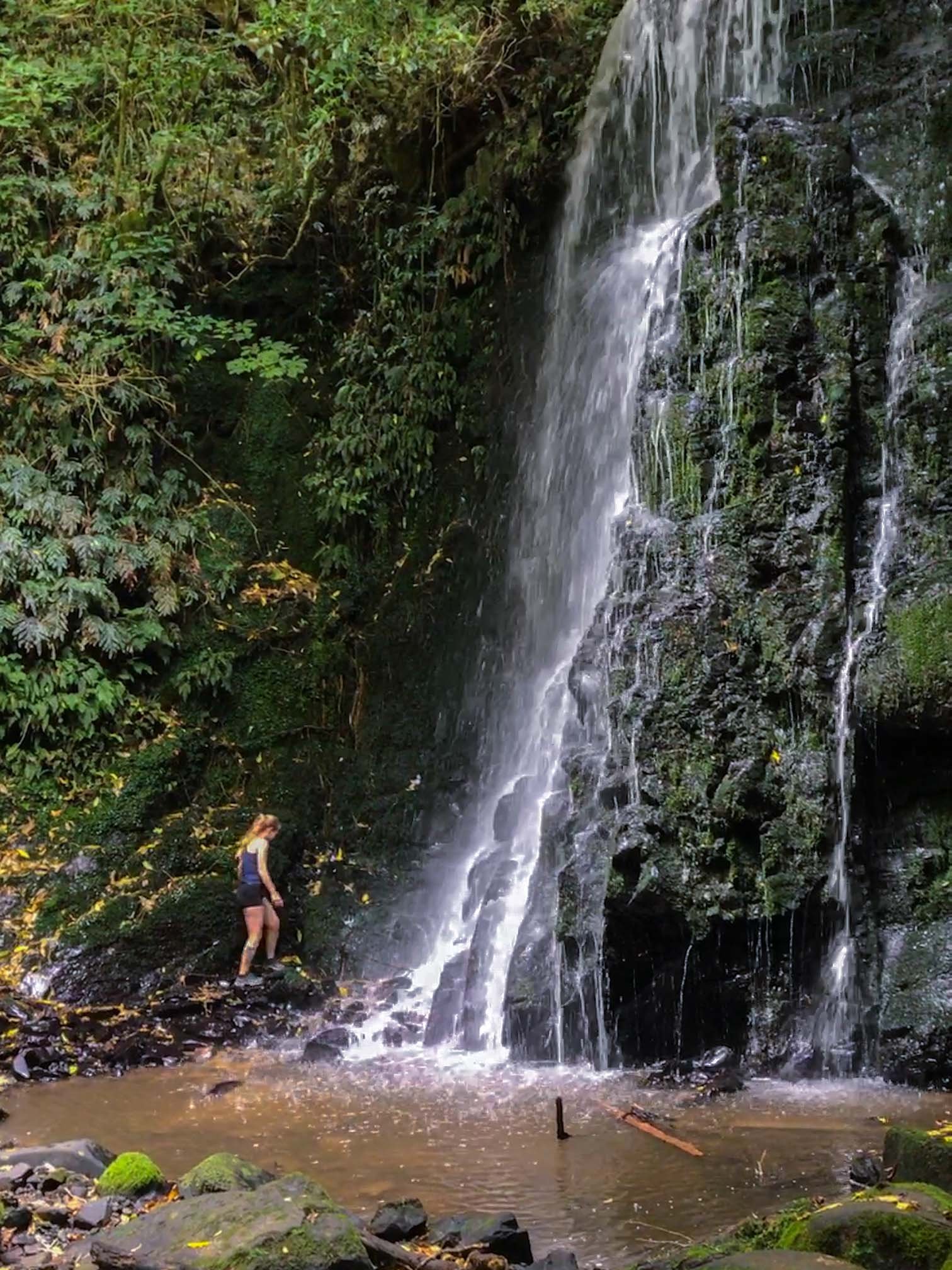
7. Koropuku Falls

My favorite waterfall in all of the Catlins: Koropuku Falls. Koropuku Falls requires only a short and sweet walk to a beautiful, private waterfall. This is an unofficial trail, but is very well maintained. It can get muddy and does require a tiny bit of hands-and-feet climbing at the end, but definitely doable for all fitness levels. Prepare for a 40 minute return walk. Of the 5+ times I’ve done this hike, I’ve only ever seen one other person on the trail! So there’s a good chance you’ll get this beauty all to yourself.
How to Get to Koropuku Falls
This trailhead is very easy to miss. You’ll have to look for a tiny sign and dirt pullout just barely large enough for two vehicles, while driving along a windy section of the Chaslands Highway. Preload these coordinates into your GPS to ensure you don’t miss it: S 46° 34' 43.0062" E 169° 13' 8.475".
8. Barrs Falls

Not the most impressive by any means, but I think it’s still worth a stop because it’s only a 5 minute walk to not one but two waterfalls! Rumored to be more full looking after rain. You’ll likely have the whole place to yourself.
How to Get to Barrs Falls
To reach Barrs Falls, drive 2km south of Owaka on the Southern Scenic Route and then turn right onto Barrs Falls Road. After driving on this gravel road for about 3km, pull over by the DOC sign and begin your walk. There’s no official car park, just a gravel pullout.
9. Niagara Falls

It’s hard for me to call this a “waterfall,” it’s more like a rushing river with a few small drops. This was ironically named and not at all like the Niagara Falls in America. You’ll see whitebait nets set up and if you’re as lucky as we were, seals playing in the water! It’s not worth a stop though in my opinion.
How to Get to Niagara Falls in NZ
Drive 1km North of Niagara along the Niagara-Waikawa Road. Turn onto Manse Road, then turn left immediately after crossing the bridge and park in the gravel. There’s a wee sign where the very short walk begins.
Planning Your Trip to the Catlins
Here’s a few tips to make your trip planning a breeze! For starters, I’ve created a map that pinpoints exactly where all of the waterfalls mentioned in this post are located. From Dunedin, it’s approximately a 2 hour drive to the Catlins and a 1 hour drive from Invercargill.
Service is spotty throughout the Catlins, so print out a map in advance or download my Google Map for offline use (click the image below)
It rains A LOT in the Catlins, and rain makes for muddy trails. There wouldn’t be so many waterfalls if it wasn’t for the rain! Bring proper footwear and a rain jacket.
Expect to drive on several gravel roads to reach a few of the trailheads.
Always check the Department of Conservation site for the most up to date trail conditions and closures.

Click the image above to view an interactive map of all Catlins waterfalls.
Other Things to Do in the Catlins
Here’s a list of some other popular walks and sightseeing activities in the Catlins Conservation Area.
Cathedral Caves Track: 2.6km | 100m | 45min
Nugget Point Lighthouse Walk: 1.8km | 100m | 40min
Jack’s Blowhole Walk: 2.7km | 120m | 1hr
Slope Point Walk: 1.6km | 40m | 25min
Waipapa Point Lighthouse Trail: 0.8km | 5m | 10min
Curio Bay, Penguin Walk and Petrified Forest Trail: 1.9km | 20m | 25min
Disclaimer: Please adventure at your own risk. The author of this article is not liable for any injuries or damage that may occur. It is up to the individual to determine their own capabilities and limits, and to thoroughly research before venturing into the great outdoors. Read our full disclaimer.


