
Jacks Blowhole Track and Jack’s Bay | The Catlins
Jacks Bay is a worthwhile detour for families road tripping along the Southern Scenic Route. Check out Jack’s Blowhole Track where you’ll get to see and hear the power that created the rugged Catlins coastline.

Frequently Asked Questions
-
The walk to Jack’s Blowhole is 2.7 kilometers long, with an elevation gain of 120 meters. It takes approximately 1 hour to complete the track.
-
Yes, Jack’s Blowhole is most impressive during high tides. The blow hole “spouting” effect is caused by powerful swells. It’s still worth visiting during low tide too though. Check the Jack’s Bay Tide Times here.
-
Yes, leashed dogs are allowed in Jack’s Bay and on Jacks Blowhole Walk.
Trail Description
| Difficulty | Distance | Trail Type | Elevation Gain | Time | Family Friendly |
| Easy | 2.7 km | out-and-back | 120 m | 1 hour | ★★★★★ |
| Difficulty | Easy |
| Distance | 2.7 kilometers |
| Trail Type | out-and-back |
| Elevation Gain | 120 meters |
| Time | 1 hour |
| Family Friendly | ★★★★★ |
5 stars for family friendliness thanks to the easy to follow and super straightforward trail.
Your GPS will take you to the end of Jack’s Bay Road where you’ll come to a dead end in front of a wooden fence stating “Private Road, No Entry.” This is where the walk starts, but you should reverse back to the parking spots about 50 meters behind you. Park along the gravel pullouts facing Jack’s Bay, just past the toilets.


Left pic taken from the parking area. Trailhead and dead end road can be seen in right pic.
From the parking spaces, you’re at most a two minute walk from the trailhead. Walk straight up the road and past the toilets (on your right). Just after passing the cute little beach shacks, the official signposted walk begins on your left. Use the wooden stiles (the A frame stairs with orange handles) to climb over the fence.

The official start of the Jack’s Blowhole Walk.
The initial 10 minutes or so of this walk is along a mostly flat dirt road, known as Jack’s Bay Road. Earlier you may have seen a sign on the fence blocking off vehicle access; only foot traffic is allowed on this part of the road. Thankfully, this means you don’t need to worry about dodging any incoming traffic on your walk! Haha assuming I’m not the only one who had that thought cross their mind.

As you walk, you’ll see densely packed trees filled with chirping birds to your right and native grassy bushes to your left. The walkway itself is a mixture of grass and well packed gravel, making the path feel relatively soft underfoot. This track does cross through private farm land several times so there will be fences alongside you majority of the way. After about 10 minutes of walking Jack’s Bay Road, you will eventually come across another wooden stile.
Did you know? A stile is an arrangement of steps allowing people (but not animals) to walk over a fence, commonly built in an A frame shape. In New Zealand, you’ll most often find these in rural areas along footpaths, fences or walls that enclose farm animals.

Another stile! Look close, there’s actually two.
Immediately after crossing the fence, you’ll see another stile but make sure to have a look out at the view on your left before passing. This spot overlooks Penguin Bay and the Tunnel Rocks. In my opinion I felt this was the most scenic and impressive view of the whole trail. In hindsight, I wished we turned back around at this point. We wanted to see the blowhole though so we carried on over the next stile.

Overlooking Penguin Bay and Tunnel Rocks (to the left).
This gentle walk turns into a moderately tiring climb very fast. There’s numerous flight of steps to climb as you make your way higher. Overall, there’s 120 meters of elevation gain on this walk and I’m willing to bet most of it is in this one section right here. Don’t get me wrong, the views around you are fairly nice, but it’s hard to focus on them when you’re so out of breath from the stairs. I kept looking down at my feet so I didn’t trip, and also kept ducking down so I didn’t hit my toddler’s head on the low hanging tree branches.

The beginning of many, many more steps to come.
The stairs do eventually come to an end though and with a bit of a reward for your hard work too. There’s a wooden picnic table there beckoning you to take a rest and catch your breath. If you’re more fit than I am (you carry a 15kg toddler up those stairs and then we’ll talk!), carry on following the gravel trail. To your right you’ll see a few large farm paddocks filled with grass and if you’re lucky, animals too!


Continuing forwards, you get a glimpse of the stunning Catlins coastline. The Catlins is famous for it’s dramatic coastal cliffs and beaches. You get a few great viewing opportunities along this walk to see where the land meets water. Photos just don’t do it justice.
Fun Fact: Jack’s Blowhole and Jacks Bay were named after the famous chief of the Maori tribe known as Ngāi Tahu. Apparently Tuhawaiki was quite fond of the saying “Bloody Jack", so much so that it became his nickname.

View of where the Catlins cliffs meet the powerful sea.
After about a half hour of total walking so far, the path veers to the right where you’ll come across this intersection. The DOC sign warns you not to lean on or climb over any fences. I’m going to have to second them on that warning, because what you are about to see will either scare you or fascinate you— or both! The path circles around the blowhole so it’s up to you to go left or right.

Warning: Do not leave on or climb over fence. Jack’s Blowhole: 55m deep, 144m long, 68m wide, 200m inland from the sea.
The entire blowhole takes maybe 2 minutes tops to walk around. You’ll be able to hear the power of the blow hole before you can see it. Please refrain from peeking through the trees until you’ve reached the wooden viewing platform, located directly next to the picnic table. This platform was specifically made for your safety. The fence surrounding the blowhole does not look sturdy enough to withstand a human body leaning against it, so don’t! Keep your curious little ones close to you too. Step on the platform, walk to the end and look down.

Overlooking the Blowhole. See the big open clearing in the trees?
I present to you: Jack’s Blowhole! The blowhole is 55 meters deep, 144 meters long and 68 meters wide. Jacks blowhole is part of a subterranean tunnel over 200 metres long. Many years ago, a cave in this sea tunnel collapsed and created the famous blowhole you see today. Witness the powerful waves that formed the Catlins coast in action as they come crashing down in every direction. The blowhole puts on quite a dramatic spouting show during high tide, so it’s worthwhile to plan your walk around the tide times.
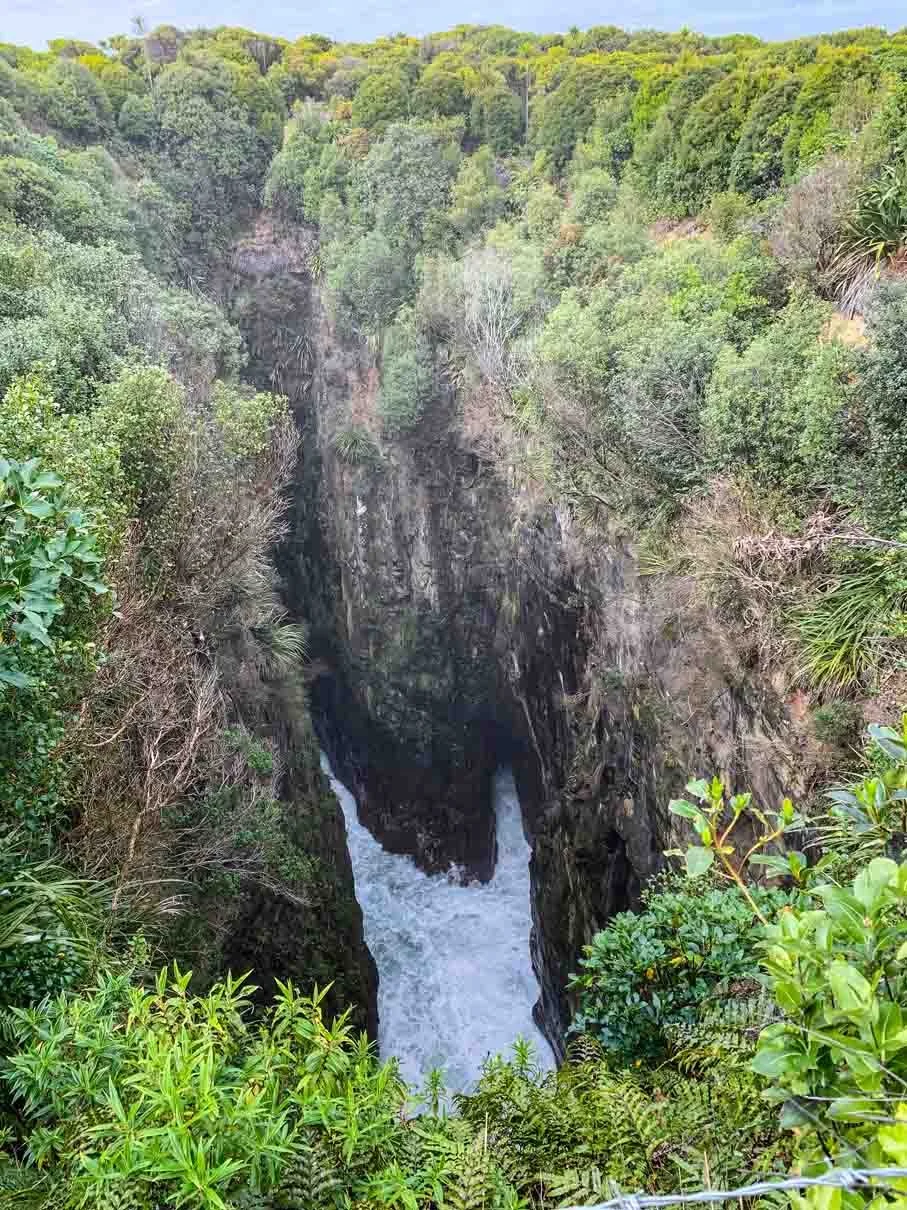
Definitely wouldn’t want to fall down there.
Complete the circular path around the blowhole before heading back the way you came. On the bright side, you’ll get to go down all those stairs you climbed earlier!
Know Before You Go:
High tide is the best time to see the blowhole in action. Click to check Jack’s Bay Tide Times.
This track may be CLOSED during lambing season: September 1st to November 1st. Check with DOC for most recent updates.
We had cell service in both Jacks Bay and on Jacks Blowhole walk.
Leashed dogs are permitted on this walk.
How to Get to Jacks Bay
From Invercargill (2hrs) via Southern Scenic Route
Head Southeast on Gorge Road-Invercargill Highway for approximately 70 kilometers where you’ll turn left onto the Chaslands Highway to begin following the Southern Scenic Route. 50km later take a right turn onto Purakaunui Falls Road. After 1.7km go left on Lakeside Rd (turns into Hina Hina Rd then Jacks Bay Rd) and within 15 minutes you’ll arrive at Jacks Bay.
From Dunedin (1hr 35min)
Head South on State Highway 1, taking the Southern Scenic Route to Balclutha. After about 125km’s (just after passing Balclutha), turn left on High Street to stay on the Southern Scenic Rte. 30 km’s later you’ll turn left onto Royal Terrace (Pounawea Rd) then turn right onto Hina Hina Rd in 900 metres. Follow the signs to stay on Hina Hina Road for about 6km’s, then turn right on Jack’s Bay Road. You’ll arrive in Jack’s Bay just a short minute later.
Other Trails Near Jack’s Blowhole
The Catlins coastal region is filled with tons of family friendly walks and scenic stops. Here’s a few more in the Clutha area:
Purakaunui Falls Walk: 0.6km | 20m | 15min
Nugget Point Lighthouse Walk: 1.8km | 100m | 45min
Cathedral Caves Walk: 2.6km | 100m | 50min
Matai and Horseshoe Falls: 1.1 km | 50m | 25min
McLean Falls Walk: 1.8km | 70m | 30min
Disclaimer: Please adventure at your own risk. The author of this article is not liable for any injuries or damage that may occur. It is up to the individual to determine their own capabilities and limits, and to thoroughly research before venturing into the great outdoors. Read our full Disclaimer.


