
Hiking the Rob Roy Glacier Track
There are so many day hikes in New Zealand to choose from, but few of them let you walk right up to the base of a glacier surrounded by cascading waterfalls. Rob Roy Glacier Track is one of those “takes your breath away” walks and is a must do when visiting Mount Aspiring National Park.

As soon as I discovered this trail, I knew I had to see it for myself in person. Despite being 6 months pregnant, I managed to handle this walk just fine and highly recommend it to all who visit Wanaka. This walk seriously has it all: a swing bridge, glacier, snow capped mountains, waterfalls, forest views and more!
Trail Description
| Difficulty | Hard |
| Distance | 10 kilometers |
| Trail Type | out-and-back |
| Elevation Gain | 500m |
| Time | 4 hours |
| Family Friendly | ★★★★☆ |
| Difficulty | Distance | Trail Type | Elevation Gain | Time | Family Friendly |
| Hard | 10 kilometers | out-and-back | 500 meters | 4 hours | ★★★★☆ |
Begin walking Northwest from the Raspberry Flat Car Park onto a flat dirt path leading into the Matukituki Valley. Expect to see a few friendly sheep or cattle as you pass through the farm land. Remember to keep a safe distance and respect the private land you are crossing through!


Having an eye staring contest with a friendly cow on the trail.
Continue following the dirt path until you are eventually walking alongside the Matukituki River. This portion of the walk offers little to no shade, but the rest of the trail passes through fully shaded, thick forest.

Facing East, looking over the West Matukituki River from atop the swing bridge.
After just 1-2km / 15 minutes, you’ll reach a swing bridge. Proceed with caution, and be prepared to wait for other hikers to fully cross before you do. Signs recommend only a few people on the bridge at a time.

After crossing the bridge you will be immediately consumed by thick, shaded forest. Your steady uphill climb begins here and continues until you reach the final viewpoint.

The track is very easy to follow and well maintained, though it’s not suitable for wheelchairs or strollers. Rocks and tree roots stick up out of the ground every few steps.

On your climb up, you’ll come along this wooden bench overlooking the stunning Matukituki Valley. Take a break if you need, but keep pushing on though as you are still far from the Glacier!

The trail follows a stream that leads directly into the Matukituki River below.

View of the bright blue glacial water flowing down the valley.
Lower Viewpoint
Congrats! You’ve earned yourself another break. After an hour and a half of climbing, you’ll come to a small clearing in the trees giving you a glimpse of the Rob Roy Glacier. During avalanche season (May - November), this may be as far as you’ll be allowed to hike and you should turn around here if so. Any other time of year though, you’ll be able to continue on to the Upper Viewpoint. (and I highly recommend that you do!)

Wooden benches at the Lower Rob Roy Glacier Lookout.
Upper Viewpoint
30 minutes later and you’ll reach this breathtaking view. SO worth the climb! You’ll see a few thin trails leading across the river and even closer to the glacier, but these are unmarked / unofficial trails so proceed at your own risk. Photo tip! To avoid harsh light or shadows on the glacier, hike in the early morning or late afternoon. When you decide you’re finished admiring the view (you won’t want to leave), turn around and head back down the way you came.
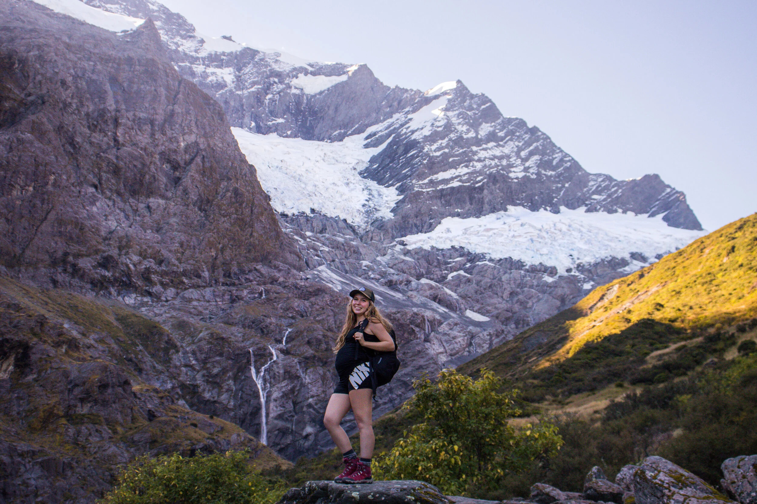


A massive waterfall seen to the left of Rob Roy Glacier.
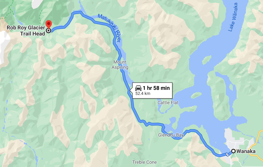
Directions (from Wanaka)
From Wanaka, head North-West on the Wanaka Mount Aspiring Road. It’s about a 50km drive and will take an hour and a half (or less, we drove in nearly 1 hour) each way. Park at the Raspberry Flat Car Park.
The last 30km of it is on an unsealed gravel road featuring several ford crossings. It is vital that you check the weather and road conditions before heading out on this road, as there is only one way in and one way out. In rainy weather, many sections of the road are washed out and flooded. A high clearance vehicle with 4 wheel drive capabilities is recommended, but not required. You will see many 2 wheel drive rental cars and campervans at the trailhead.

Safety First
Planning in advance is the number one thing you can do to stay safe while out in the wilderness. Here are a few things to prepare for before your trip to ensure a safe hike:
Ford Crossings: On your way to the trailhead, you will drive on an unsealed gravel road for 30km. This road contains around 10 small ford crossings that may be completely washed out or flooded in bad weather. A high clearance, 4 wheel drive vehicle is ideal but not at all necessary to reach the trailhead. You will see many 2 wheel drive rental cars and campervans at the trailhead. Check the DOC website for the most up to date road and weather conditions.
Avalanche Season: From May to November, it is highly recommended you check the New Zealand Avalanche Advisory website before your trip. During winter this trail is often closed or restricted to just the Lower Lookout because it is in complex avalanche terrain.
Alpine Weather: The weather can change very quickly and unexpectedly, bring extra warm layers and a waterproof jacket.
Steep Drop Offs: Some sections of the trail are right alongside steep drop offs. Be extra careful with your footing and make sure to keep children away from the edge.
No Cell Service: There is no cell service at the trailhead. Inform someone of your plans ahead of time. Tell them exactly where you are going, and what time you expect to be back by.
Frequently Asked Questions
-
The Rob Roy Glacier Track is just over 10 kilometers long, or 6.4 miles.
-
The Rob Roy Track is open year round, up to the Lower Viewpoint. The walk to the Upper Viewpoint may be inaccessible from May to November if there is a risk of avalanche. Check the Avalanche Advisory Site to determine avalanche likelihood.
-
4WD is ideal but not at all necessary, no. It depends if it has rained recently or not. Always check road conditions and weather before you go.
Other Trails in the Area
There are several other tracks and huts to check out in Mount Aspiring National Park. Here’s a few worth checking out:
Wishbone Falls: 10min return
West Matukituki Track: 9km to Aspiring Hut, 15km to Liverpool Hut, 16.2km to French Ridge Track
Shotover Saddle Route: 4km return
Where to Stay in Wanaka
Disclaimer: Please adventure at your own risk. The author of this article is not liable for any injuries or damage that may occur. It is up to the individual to determine their own capabilities and limits, and to thoroughly research before venturing into the great outdoors. Read our full disclaimer.


