
Borland Nature Walk | Fiordland National Park

Carefully crossing the suspension bridge found on the Borland Nature Walk.
The Borland Nature Walk is a short half hour loop taking you through beechy forest, over a suspension bridge and along the Borland Burn River. Accessible via Borland Road and conveniently located just across from Borland Lodge.
In This Trail Guide:
Borland Nature Walk Map

Created by Mountain Mamas NZ - Image sourced from LINZ - Crown copyright ©
| Difficulty | Easy |
| Distance | .5 kilometers |
| Trail Type | Loop |
| Elevation Gain | 30 meters |
| Time | 35 minutes |
| Family Friendliness | ★★★★★ |
| Pram Access | Up to bridge |
| Dog Access | No |
| Trailhead Coordinates | 45°46'33.3"S 167°32'11.5"E |
Note: This track is only stroller and wheelchair accessible up to the bridge.About the Borland Nature Walk
The Borland Nature Walk trailhead is a small gravel carpark located just across from the Borland Lodge. This is also the starting point for the treks to North Borland Hut, Rock Bivvy and Eldrig Peak. There aren’t any toilets here, but you may be able to ask nicely to pop into the lodge and use their facilities if needed. Anyways, all walks start on the same path leading out of the parking area.


DOC signs state most walkers will finish in 20 minutes, but it took us closer to 30 minutes to complete the full loop. There’s half a kilometer of walking before you reach the bridge. This first section of the path is very flat and smooth, meaning it’s both wheelchair and stroller accessible! Even though going over the bridge was our favorite part, there’s still several worthwhile viewpoints to see before then if you only want to do the accessible part of the trail.

Walking through the many silver and mountain beech trees.

At least 10 of these structures were standing when we went, some with moss growing on top of them!
Right off the bat, kids will love this walk. A small community of huts made from tree branches can be seen alongside the walkway. Our toddler had no interest in them shockingly, but we thought they looked quite neat. Some of them looked pretty old too, with green moss growing over the top of them. Trees are spaced out far and wide through here, leaving lots of open ground exposed. Dapples of sunlight peek through the trees occasionally, but overall this area is heavily sheltered in.


In the first 10 minutes there will be a couple spots to view Pig Creek before it intersects with the Borland Burn River. The creek is very shallow and provides a crystal clear view of the colorful rocks at the bottom. Sounds of running water will follow you around this track, making it extremely peaceful and potentially sleep inducing… if your little ones are used to sleeping with a sleep noise machine that is!


Soon enough you’ll reach the suspension bridge crossing over Pig Creek, marking the end of the wheelchair / pram accessible part of the walk. From the top and as you look down below you, you get a clear view through the yellow tinged water. The bridge is very stable and fully fenced in from the waist down, so super kid friendly.


Make it stand out
After crossing the bridge, you’ll begin on the loop section of the track. It’s up to you whether you’d like to go left or right first. Just remember, the path branches off onto several other walks from here, so make sure to follow the arrows on the dark green and yellow DOC signs directing you on the Nature Walk Loop. If you go left, stay on the paths to your right. If you go right, stay to the paths to your left til looping back around to the bridge. We decided to go right!
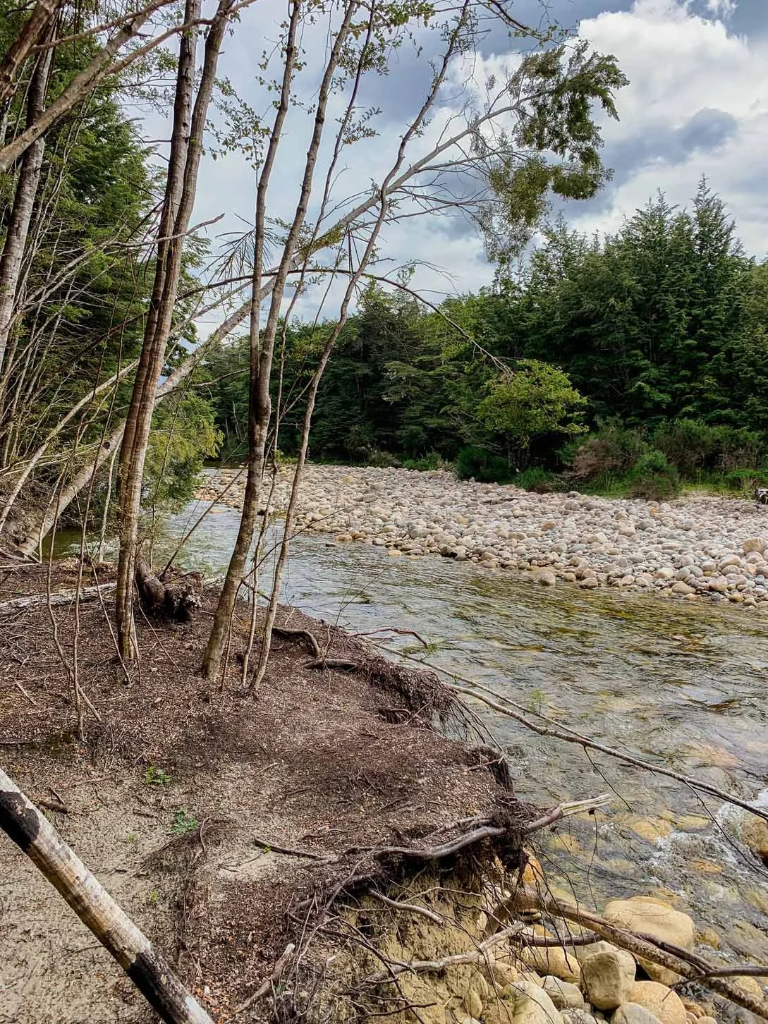
Along the loop, there’s one small break in the trees revealing a glimpse of the Borland Burn River. You can walk out to the edge for a better view of the water, but unless you want to get your feet wet you won’t see much beyond what I’ve captured in the photos above. It’s still a neat highlight though and you can’t beat the sound of the rushing water next to you.

Continuing on, you might notice a lot of fungi around. Shockingly, there were tons of different shapes and colors of mushrooms growing in the middle of summer. Most were growing along fallen tree trunks that have now been taken over by soft green moss. Some were growing up the sides of extremely tall trees, look up every couple minutes and you’ll see them too! Fun fact: this is the best spot in all of Southland to see a native red mistletoe plant, often flowering in early summer.


Since we initially went right at the start of the loop, we stuck to the left as we circled our way back towards the bridge. Carefully reading each sign to ensure we stayed on the correct trail. The loop takes at most 20 minutes total, then from the bridge it’s a further 5 minutes back to the parking area. If your kids love walking over the bridge as much as mine did though, it might be a bit longer for you! Haha

Carefully peeking down at the water below.
Frequently Asked Questions
-
Yes, the Lake Borland Nature Walk is super family friendly. The path is stroller and wheelchair accessible up to the bridge.
-
No, dogs are not allowed on any of the walks starting from Borland Lodge.
-
No, you do not need 4 wheel drive to reach Borland Lodge outside of winter. Always check the Borland Road conditions before heading out, as it is frequently closed in winter.
How to Get to Borland Lodge
The Borland Nature Walk trailhead is approximately 45 minutes north of Tuatapere and 40 minutes south of Lake Manapouri. Along the Blackmount-Redcliff Highway, take the turn off for Lake Monowai Road. From the turnoff, you begin driving on an unsealed gravel road. In 8 km’s the road veers left and right, go right to start on Borland Road (the left road takes you to Lake Monowai). Borland Lodge is on your left in 4 kilometers and the trailhead is on your right just across from it.
Note: 4 wheel drive is not required to reach Borland Lodge, but it is recommended if you wish to go any further on Borland Road. This is a private road that’s usually not suitable for rental cars, and is definitely not suitable for caravans, campervans and other large vehicles. Always check Alerts for Borland Road Area before heading out.Other Things To Do Along Borland Road

The most popular walks and huts accessible from Borland Road.
As you can see on the map above, Borland Road is jam packed full of outdoor adventures. There are day walks, overnight tramps to backcountry huts, trout fishing, deer hunting, freedom camping, swimming and boating options too. Here’s a few other activities to check out in the area:
Stay at Borland Lodge: Rent a bunk, cabin or chalet to stay right in the heart of this remote and isolated area. Easily accessible and very conveniently located close to most activities Borland Road has to offer.
Camp at Lake Monowai: Just a 20 minute drive from this trailhead is a free DOC campground open to all non self contained visitors. Offering toilets, picnic tables and fire pits.
Walk to the Lake Monowai Peninsula Lookout:
3km | 5m | 30 minHike the Mount Burns Tarns Track:
1.4km | 200m | 1hrHike the Burnt Ridge Track:
5.3km | 120m | 1hr 20min
Disclaimer: Please adventure at your own risk. The author of this article is not liable for any injuries or damage that may occur. It is up to the individual to determine their own capabilities and limits, and to thoroughly research before venturing into the great outdoors. Read our full Disclaimer.


