
Lake Alta Track | The Remarkables (Queenstown)
Lake Alta, the glacial lake sitting a remarkable 1800 meters above sea level.
// Note: The content on this page may contain affiliate links for outdoor products or experiences I highly recommend. If you make a purchase after clicking one of these links, I earn a commission which offsets the cost of running this website. //
One of the shortest, yet remarkably scenic walks in The Remarkables is the Lake Alta Track. Hike beyond the ski resort to an alpine lake hidden amongst the mountains. A great track for families with multiple options to go further.
In This Trail Guide:
Lake Alta Track Map

Created by Mountain Mamas NZ - Image sourced from LINZ - Crown copyright ©
| Difficulty | Moderate |
| Distance | 3.4 kilometers |
| Trail Type | Out-and-back |
| Elevation Gain | 200 meters |
| Time | 1hr 30 min |
| Family Friendliness | ★★★★★ |
| Pram Access | No |
| Dog Access | On Leash Only |
| Trailhead Coordinates | 45°03'10.9"S 168°48'48.0"E |
Note: Lake Alta may also be reached from the Wye Creek Track, a lengthy and steep walk that's approximately 15km's / 6 hours ONE WAY. I recommend arranging a vehicle swap to shorten the track.Hiking to Lake Alta
You have two options to get to Lake Alta: Walk straight to Lake Alta and back, or turn this into a loop by completing the Shadow Basin Circuit (only 30 minutes extra). In the summer months the Remarkables Ski Field Buildings are closed, so your only toilet options are the portaloos in the lower gravel parking lot. Make sure everyone takes a wee now and begin to walk up the gravel road heading to the right side of the ski resort.

Image Source: Rubi Edillo Blogs via Facebook
Once you pass the building the gravel path gets a bit lost, but keep heading uphill towards the ski lift conveyor belt. Those heading to the Shadow Basin Lookout will turn right early on and follow a different gravel road just before the start of the fully enclosed conveyor belt ski lift. Carry on alongside the ski lifts and continue climbing uphill as you pass them.

Looking back towards the ski resort and ski lifts.
As you climb further away from the ski resort, follow the gravel road as it zig zags in the direction of the chairlift. Stick to the right because halfway into the walk there is another gravel road that veers left and crosses over Wye Creek. The correct road to stay on will slowly wind around to the right and cross over Wye Creek much later on in a rocky section.

Following the skifield road higher up towards the Remarkables.
Around you the rocky Remarkable mountains stand tall and are covered in scrub like bushes. Halfway into the Lake Alta walk the trail turns from compacted down gravel to a narrow and soft dirt path. By the end you’ll be rock hopping and trying not to roll your ankles. If you’re lucky enough to visit in late spring or early summer, there might be patches of snow melting alongside the walk. Sometimes Lake Alta is still frozen over as late as November!

Wye Creek flowing to the left of the Lake Alta Track.
Around 30 to 45 minutes of hiking, you’ll see a small portion of the Wye Creek to your left. Do not cross this water! The correct route goes to the right and up the mountain, you’ll see an orange triangle marker to lead the way. The path narrows and slowly gets rockier and rockier as you go. A few switchbacks to go and Lake Alta should start to come into view.

Where the gravel road ends and the dirt path begins. Follow the orange markers from here forward.
A few streams run down the mountain, making the perfect white noise to shush a wee bubba to sleep while you walk. They’re all fairly easy to cross with dry rocks to step on. A bit of scrub and mossy rocks start to close in on the track as there’s only seasonal foot traffic beyond this point.

Crossing over Wye Creek as we neared the Lake it flows out of!
Even in the midst of summer, the Remarkables can be remarkably cold. It is alpine territory and you should always prepare for cold, windy and wet alpine conditions. We brought our 6 month old baby with us and definitely didn’t bring enough layers. Down in Queenstown it was hot and sunny, up in the mountains it was windy and freezing cold. To keep my baby as warm as possible, I made a last minute decision to take him out of his carrier and nurse him inside my sweatshirt for the remainder of the hike.


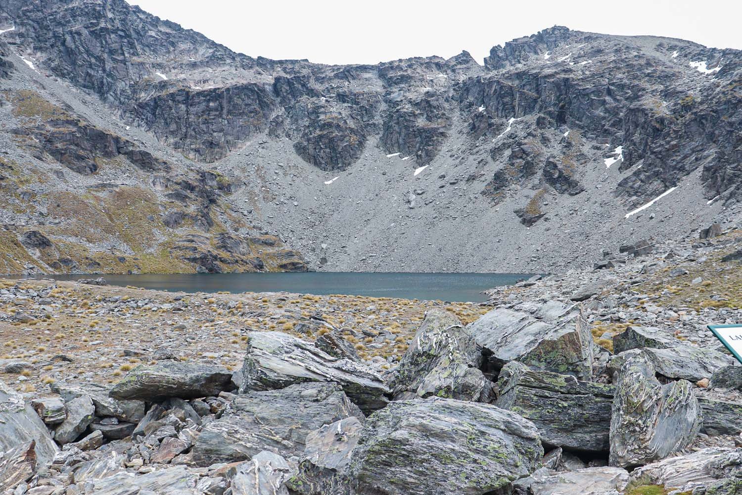
An hour of uphill hiking later and we arrived at the Lake Alta Track lookout point. A few informational signs let us know that this Lake sits an impressive 1800 meters above sea level, is 500 x 250 m wide and about 15 m deep. My favorite time to do this track is while there’s still a bit of snow on the mountains in late spring or early summer. You can walk another 5 or 10 minutes beyond this point to reach the actual lake water. Brave souls are welcome to take a chilly dip!

Lake Alta with our 6 month old baby, January 2022.
Return back to the carpark on the same path you followed in. Don’t forget to stop at a lookout on the drive back down and snap a pic! The views are seriously remarkable.
Frequently Asked Questions
-
Yes, you can swim in Lake Alta as long as the ice has melted. It can be extremely cold though even in the peak of summer.
-
Lake Alta in the Remarkables is approximately 15 meters deep (50 feet), 500 meters long and 250 meters wide.
-
The Lake Alta Walk in the Remarkables is 3.4 kilometers (2.1 miles) long. It takes approximately 1 hour and 30 minutes to complete the out-and-back track.
-
The Lake Alta Track is a moderately challenging uphill walk on a semi rocky path. It’s a good challenge for beginners and families, but could be on the easier side for more experienced hikers.
How to Get to Lake Alta
From Queenstown (40min)
From the city centre, take State Highway 6A Southeast towards Frankton (about 6km’s). At the Frankton roundabout, take the 3rd exit to get on SH6 (signs for airport). In 4 kilometers turn left onto The Remarkables Ski Field Access Road and 13km’s of slow, windy and steep gravel road later you’ll reach the car park! In the summer months, 16 December to 30 April, there’s a $10 road toll (card only) to be able to do the scenic drive and reach the Lake Alta Walk.
Other Things To Do in The Remarkables

Image Source: Tony Harrington | Shadow Basin Lookout
Other Remarkables Walking Tracks:
Shadow Basin Circuit (Shadow Basin Lookout pictured above)
5.6km | 400m | 2hr 30minDouble Cone Track
7.2km | 660m | 3hr 20minThe Masters Traverse Loop
11.7km | 780m | 6hr 30min
Ski, Snowboard or Sled: The Remarkables Ski Field is one of two ski resorts near Queenstown offering 7 parks, 4 chairlifts, sightseeing passes, rentals, lessons and some extremely scenic lookouts.
Scenic Helicopter Flight: All ages welcome (infants too) on this 20 minute heli tour departing from Queenstown and landing in the Remarkables mountains.
Where to Stay Near the Remarkables
Disclaimer: Please adventure at your own risk. The author of this article is not liable for any injuries or damage that may occur. It is up to the individual to determine their own capabilities and limits, and to thoroughly research before venturing into the great outdoors. Read our full Disclaimer.


