
Castle Hill Walk via the Kura Tawhiti Access Track in Arthurs Pass
Visit Castle Hill Conservation Area and take a walk around impressive limestone rock formations via the Kura Tawhiti Access Track. A must do in Arthur’s Pass for both walkers and scenic stoppers. Let your imagination run wild while exploring this natural stone playground.

Trail Description
| Difficulty | Distance | Trail Type | Elevation Gain | Time | Family Friendly |
| Easy | 5 km | loop | 250 m | 90 min | ★★★★★ |
| Difficulty | Easy |
| Distance | 5 kilometers |
| Trail Type | loop |
| Elevation Gain | 250 meters |
| Time | 1 hour 30 min |
| Family Friendly | ★★★★★ |
You can easily shorten or lengthen your walk as desired, these stats are from following the loop track to the top of Castle Hill and back.
Make your toilet stop now because there are no other loos on the trail and you might be exploring longer than expected. This place is pretty spectacular, after all Castle Hill is where they filmed the battle scenes for The Chronicles of Narnia movie. Call this a family friendly favorite!
The trail head is easily visible from the gravel parking lot, with a large sign next to a small opening in the wood fencing. If you’d like to go the quickest route to the top of Castle Hill, I recommend downloading a map in advance or using an offline navigation app like AllTrails. There are numerous unmarked side trails of various difficulty levels, making it easy to accidentally extend your climb.

Castle Hill Conservation Area Car Park

Kura Tawhiti Access Track Trail Head

Toilets at the Castle Hill / Kura Tawhiti Car Park
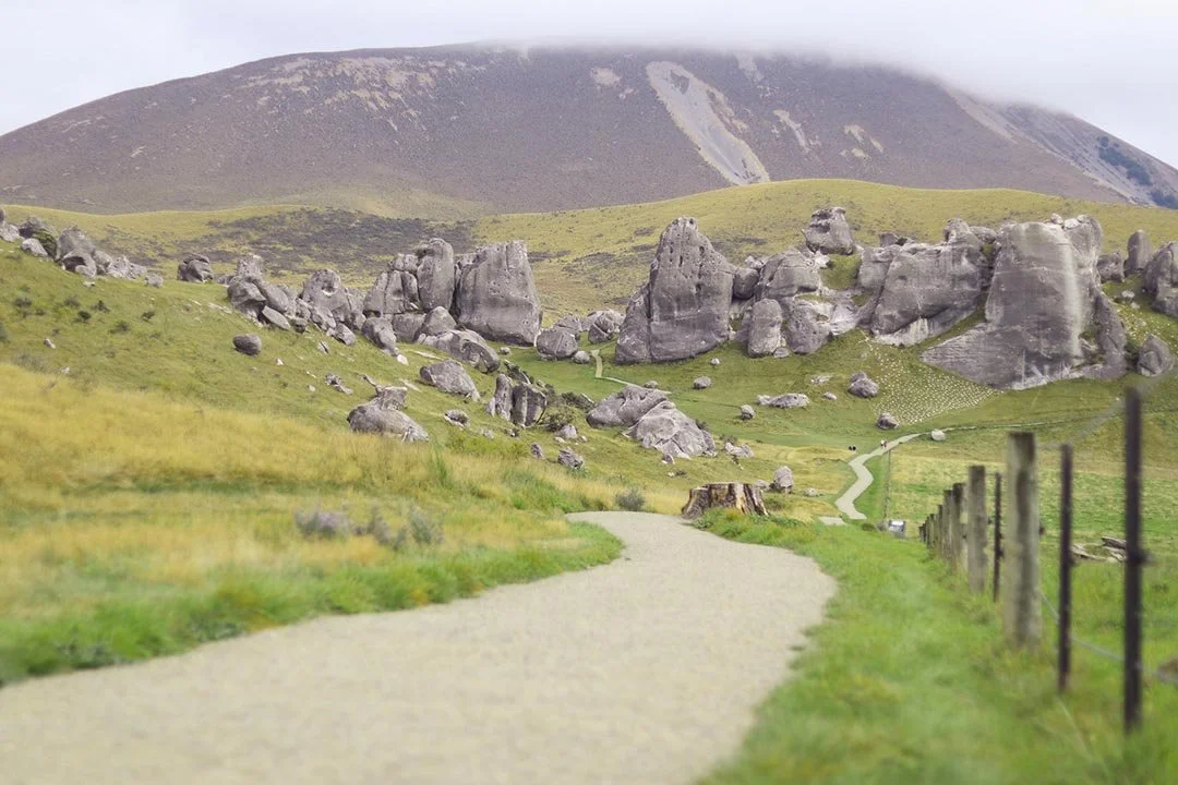
The first half kilometer of the walk is on a smooth gravel track just beside a fenced in grass area. It’s super flat, super straight and brings you right to the base of boulders nearly 30 meters tall! For some people, this is all they will need to see to get the gist of the place. But for those more curious like myself, you’ll want to do the full loop track as well as all the side trails.
The dirt path circles around the rock formations, so your experience won’t differ much whether you go clockwise or counter clockwise. You’ll be able to see the same views in either direction. We decided to head right.

The Castle Hill Conservation Area is currently under restoration with native replanting, so some parts of the trail are temporarily blocked off. Rest assured though, it is only a small section and you are still able to complete the loop. The pathway cutting through the center was not accessible when we went in March 2022.

Once you begin on the circular loop, you’ll slowly climb uphill. The rolling hills of Craigieburn Forest Park will come into view as you get higher. There are a few short stairs along the way, which are helpful to prevent slips on the loose gravel.

Boulders along the Castle Hill Walking Trail

Limestone rock formations on Castle Hill
Look closely and you might find a few small caves and rock drawings. This area played a very special role in the lives of many indigenous people. The Maori tribe Ngāi Tahu named this land Kura Tāwhiti, meaning “the treasure from a distant land.” These rocks served as shelters and a base for gathering food for many centuries.
Kura Tāwhiti is under Tōpuni status to ensure its historical, cultural and spiritual significance is recognized and respected. So while you may be tempted to rock climb the boulders in Castle Hill, please know that it is discouraged and considered disrespectful to the Ngai Tahu tribe.

Don’t forget to take in the scenery besides the rocks! As you return to the front of the loop, you’ll overlook the Torlesse mountain range and basin beneath it. Look closely and you can even see Porter River from the top of the hill.

View of Torlesse Mountain Range from Castle Hill
Begin to make your way downhill when you’re ready to go back and return the way you came via the Kura Tāwhiti Access Track. This will bring you straight back to the car park.

Know Before You Go:
There’s little to no shade on the trail, though you can easily find shelter beneath a rock or cave as needed.
If you choose to climb rocks despite the tapu status, you’ll want good grip shoes. Rocks may be slick and slippery after rain.
This area is not dog friendly, so please leave the pups at home.
Even though this is the filming location of several famous movie scenes, you’re not allowed to film your own! No drones allowed.
Check the Department of Conservation site for the most up to date trail information and closures.
Directions (from Christchurch)
From Christchurch, take State Highway 76 towards the West Coast. After 4 km take the exit heading towards Hwy 73, then use the third exit at the roundabout. In about 2.5km you’ll turn left onto Hwy 73. Drive a further 8km before making a right turn onto Old West Coast Road (heading towards Waddington). 40km later turn left onto Inland Scenic Route 72 / Waimakariri Gorge Road (State Highway 73 / Arthurs Pass). In another 40km you will see a large gravel parking lot on the left side of the road, this is the Castle Hill Carpark.
Other Trails Near Castle Hill
Devil’s Punchbowl Falls: 1.8 km | 100 m | 35 min
Cave Stream Loop Track: 1 km | 40 m | 20 min
Bridal Veil Falls: 1.4 km | 50 m | 25 min
Where to Stay in Arthur’s Pass Village
Disclaimer: Please adventure at your own risk. The author of this article is not liable for any injuries or damage that may occur. It is up to the individual to determine their own capabilities and limits, and to thoroughly research before venturing into the great outdoors. Read our full disclaimer.


