Sawyer Burn Track | Kidds Bush Reserve Hike

Panorama over Lake Hawea, as seen from the Sawyer Burn bushline.
The Sawyer Burn Track is a steep uphill climb offering panoramic views over Lake Hāwea Conservation Park. Do the day hike to the bush line, tramp overnight to Sawyer Burn Hut or carry on to Sentinel Peak. There’s an option to suit all fitness levels.
In This Trail Guide:
Sawyer Burn Track Map & Stats

Created by Mountain Mamas NZ - Image sourced from LINZ - Crown copyright ©
| Difficulty | Hard |
| Distance | 5 kilometers |
| Trail Type | Out-and-back |
| Elevation Gain | 500 meters |
| Time | 3 hours |
| Family Friendliness | ★★★★☆ |
| Pram Access | No |
| Dog Access | No |
| Trailhead Coordinates | -44.440201, 169.260537 |
Note: These stats are not for the full walk to Sawyer Burn Hut, this is just to the bushline / lower viewpoint. Allow 5 hours / 8 kilometers / 550 metres return for the walk to Sawyer Burn Hut.About Sawyer Burn Track
The trailhead for the Sawyer Burn Walk is located directly across from the Kidds Bush Reserve Campsite. It’s worth checking out before or after your walk because there are toilets, sinks and picnic tables. Along the gravel road, directly opposite the campground entrance, you’ll see a wooden gate and right next to it a green and yellow DOC sign. Two walks start from here: the Kidds Bush Forest Walk and the Sawyer Burn Hut Walk. Enter the gate to start your journey.

The trailhead. Don’t forget to shut the gate behind you, there is livestock nearby.
Within 5 minutes of starting the walk you’ll come to an intersection. Go left up the mountain to carry on towards Sawyer Burn, or alternatively you can go right to do the half hour Kidds Bush Forest Walk. Until you reach the bushline in about 2 hours, you’ll be walking uphill through the shady forest. It’s super moist and cool due to the lack of sunlight coming through the trees, creating the perfect conditions for mushrooms to grow. We saw so many colorful and funky shaped fungi on our walk, the kids always love to admire them.


At first the trail is very soft underfoot. There’s a lot of mushy green moss and fallen leaves atop the ground which can become muddy and slippery in wet weather. As you climb higher up the mountain it becomes more dry and rocky though.

Following the orange triangles up the mountain to Sawyer Burn.
After about 30 minutes of hiking and a series of switchbacks, you’ll eventually get your first glimpse of Lake Hawea. The trail becomes even steeper and a lot more rocky from here forward. Proceed ahead to keep on climbing because you have plenty more switchbacks to go. It’s so worth it though, the view opens up so much more the higher you go.


You know you’re nearing the bushline when it starts to get super rocky underfoot and there are less and less trees around you. Lake Hawea and the surrounding mountain ranges come more into view after the first hour of walking. Keep your eyes on the ground though because it’s super easy to roll your ankles or trip up in this section. Tree roots and rocks stick up out of the ground, the path narrows and the edges drop off quite far. A fall here could be quite dangerous. Especially when coming back downhill, since it’s so steep.


Around an hour and a half into the track, you’ll emerge out of the thickest part of the forest. Overgrown scrub and bushes surround the now narrow dirt path. Looking across Lake Hawea and to the right you can even see Isthmus Peak and Mount Burke. On a calm day, the water gives a clear reflection of these mountains which makes for a really great photo. The views here are great, but soon they’ll get even better.
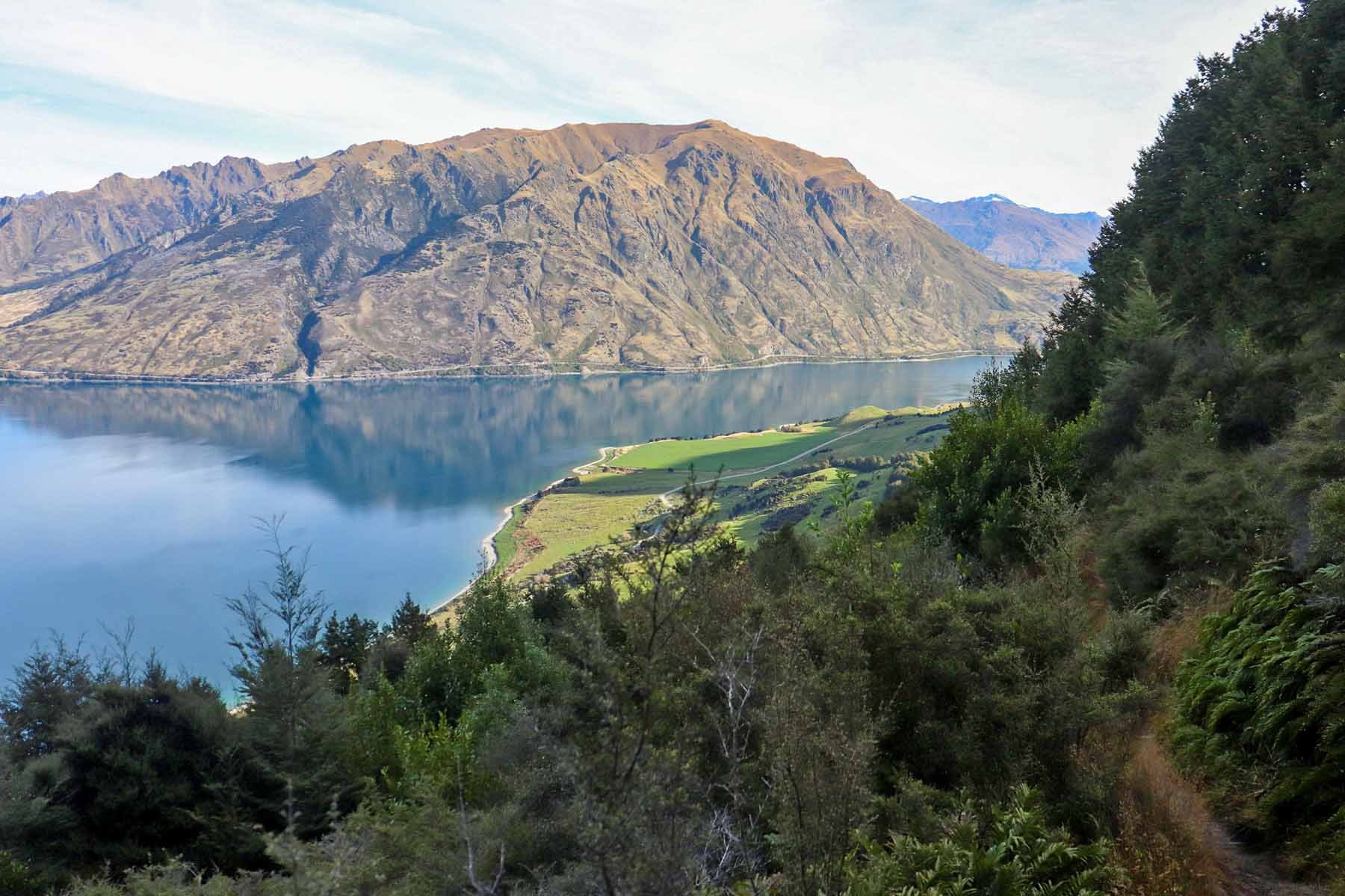
Isthmus Peak and Mount Burke in the distance.
After a few more minutes of walking, the bushes and scrub all clear as you step out into a mostly open patch of dirt. You made it! We reached the bushline and lower viewpoint in just over 2 hours. Some people reach it a little sooner than that, but I was 8 months pregnant when I did this walk so I was a bit slower than usual. If you have kids with you I imagine you’ll take longer like we did.

8 months pregnant and squeezing in as many hikes as possible before bubs arrival!
There’s plenty room here to spread out, have a snack break and soak up the breathtaking views in front of you. Take your time because you’ve truly earned it!
From here, you have two options. Option 1: Return the way you came and go back down the mountain, about 1 hour to the campsite. Option 2: Continue climbing up to Sawyer Burn Hut, about 1 hour away from the bushline.
Sawyer Burn Hut

Image Source: Tiny Tramper ©
5 hours return
8 kilometers
550 metres
The walk to Sawyer Burn Hut is mostly flat once you pass the bushline. The narrow path sidles around the hill and requires much less effort than the previous 2 hour climb did. It’s completely free to stay here and you don’t need to seek advance permission. The hut has 4 bunks with mattresses, open fire heating and a natural water source nearby. You can also carry on to Sentinel Peak from here too. Julie at Tiny Tramper has a ton of great pics if you want to see exactly what the walk to Sawyer Burn Hut entails, check it out!
Frequently Asked Questions
-
The GPS coordinates for Sawyer Burn Hut are -44.41577002, 169.25702250.
-
No, dogs are not allowed on the Sawyer Burn Track.
-
Avalanche risk is present from May through November. Check the NZ Avalanche Advisory site for the Wanaka Region.
-
The Sawyer Burn Track up to the bushline is pretty safe for kids. From the bushline to the hut, the path becomes narrow with steep drop offs next to you. I would only proceed past the bushline with young babies or toddlers if they were being carried the entire way.
How to Get to Kidds Bush Reserve

Enter your location for specific driving directions to the Sawyer Burn Track in Kidds Bush Reserve. (Opens in new tab)
From Wanaka (40min)
Take State Highway 84 East of Wanaka and turn left onto State Hwy 6, heading towards Lake Hawea / West Coast. Follow the highway for 34 km’s and then turn right onto Meads Road. Follow this gravel road for about 6 kilometers and park outside of the Kidds Bush Reserve Campsite. The gate to the trailhead is to your left.
Other Things To Do in Lake Hawea Conservation Area

Taken on Meads Road, while driving out of Kidds Bush Reserve. (I pulled over to take the pic)
Lake Hāwea Conservation Park is an outdoor lover’s paradise. You’ll find plenty opportunities for tramping, fishing, hunting, camping, swimming and mountain biking. Here’s a few activities worth checking out nearby.
Camping: Stay at a nearby DOC campground such as Kidds Bush Reserve Campsite or Boundary Creek Campsite.
Kidds Bush Nature Walk:
1.1km | 50m | 25 min
Boundary Creek Track:
12.9km | 815m | 5hrIsthmus Peak Track:
15.5km | 1,120m | 6hr 45min
Where to Stay in Hawea
Disclaimer: Please adventure at your own risk. The author of this article is not liable for any injuries or damage that may occur. It is up to the individual to determine their own capabilities and limits, and to thoroughly research before venturing into the great outdoors. Read our full Disclaimer.